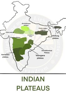
Bundelkhand Uplands Baghelkhand Region
  • Bounded by the Yamuna River, Madhya Bharat Pather, Vidhyan Scraplands, and Malwa Plateau.
  • It is the oldest dissected upland of the Bundelkhand gneiss, composed of granite and gneiss, which spreads across Uttar Pradesh and Madhya Pradesh.
  • The average elevation of the region is 300 – 600 m.
  • It is covered with black soil.
  • Rivers in the region are the Ken, Betwa, and Dhasan.
  • Located east of the Maikal range.
  • The central part of the plateau acts as a water divide between the Son drainage system in the north and the Mahanadi river system in the south.
  • General elevation varies from 150 m to 1,200 m.
  • The region is composed of limestone and sandstone.


Source: The Indian Express

📄 Download PDF