Why in the news?
- A 7.4 magnitude earthquake hit Kamchatka Peninsula.
Kamchatka Peninsula and Tectonics in the Region
- Kamchatka Peninsula
- Location: The Kamchatka Peninsula is a 1,250-kilometre-long peninsula in the Russian Far East. It includes the Kamchatka Peninsula, the Commander Islands, and Karaginsky Island constituting the Kamchatka Krai of the Russian Federation.
- Borders: The Pacific Ocean and the Sea of Okhotsk make up the peninsula’s eastern and western coastlines, respectively.
- Highest Peak: Highest active volcano in Eurasia, Klyuchevskaya Sopka (4750 m).
- Recognition: The Kamchatka peninsula contains the volcanoes of Kamchatka, a UNESCO World Heritage Site.
- Kamchatka’s Seismic Activity
- Tectonic Setting
- The Pacific Plate is subducting beneath the Okhotsk Plate along the Kuril-Kamchatka Trench (~10 km deep).
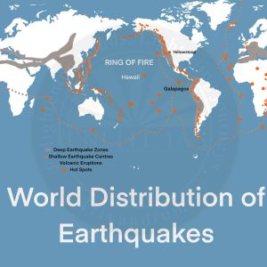
- Ring of Fire
- Kamchatka lies on the Pacific Ring of Fire – a seismically active horseshoe-shaped zone (~40,250 km).
- Ring of Fire encompasses tectonic boundaries of Pacific, Eurasian, North American, Philippine, Nazca, and other plates.
- It hosts 75% of the world’s active volcanoes and 90% of its earthquakes.
- Tectonic Setting