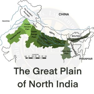
Trans Gangetic Plains
- Rajasthan Plain
- Rajasthan plain borders the Thar desert (called Marusthali) in the west and Aravallis in the east.
- This plain is an undulating plain (wave-like) whose average elevation is about 325 m above mean sea level.
- The eastern part of Marusthali is rocky and the western part is covered by shifting sand dunes called Dhrian.
- The region receives a rainfall of 25cm.
- It is spread over Gujarat, Rajasthan, and Punjab.
- One of the major inland rivers in the region is Luni which drains into the Rann of Kutch region.
- The irrigation system in the region is the Indira Gandhi Canal.
- Salination of Lakes in the Region
- Major saline lakes are Sambhar, Didwana, Degana, Kuchaman, etc. The largest is the Sambhar lake near Jaipur.
- The reason for salination is the high evaporation rates.
- Punjab – Haryana Plain
- This plain is formed by five important rivers of the Indus system.
- The plain is primarily made up of doabs (the land between two rivers having a homogenous appearance). Five doabs of the region are –
| Name of Doab | Rivers |
| Indus Sagar Doab | Between the Indus and the Jhelum rivers |
| Chaj Doab | Between the Jhelum and the Chenab rivers |
| Rachna Doab | Between the Chenab and the Ravi rivers |
| Bari Doab | Between the Ravi, Beas and Sutlej rivers |
| Bist Doab | Between the Beas and the Sutlej rivers |
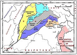
Pic Credit – Wikimedia Commons
-
- The eastern boundary of the Punjab Haryana plain is marked by the subsurface Delhi-Aravali ridge.
- The average elevation of the plain is about 250 m above mean sea level.
- The only river between the Yamuna and the Satluj is the Ghaggar which is considered to be the present-day Successor of the legendary Saraswati River.
- This is the largest unit of the Great Plain of India stretching from Delhi to Kolkata.
- The Ganga along with its large number of tributaries originating in the Himalayas have brought large quantities of alluvium from the mountains.
- The peninsular rivers such as Chambal, Betwa, Ken, Son, etc also contributed to the formation of this plain.
- The general slope of the entire plain is sloping to the east and the southeast.
- The region is marked by local prominences such as levees, bluffs, oxbow lakes, marshes, ravines, etc.
- The regional division of Ganga Plain
- Upper Gangetic Plain
- Extensive in Uttar Pradesh
- It is divided into
- Middle Gangetic Plain
- It is divided into
- Mithila Plain – Between Gandak and Kosi (Sorrow of Bihar)
- Magadh Plain – Located east of River Son
- It is divided into
- Lower Gangetic Plains
- Located along the foothills of the Shiwaliks. Plains are named Bengal Terai which is locally called Duars.
- South of Terai are Bengal Bangar plains and they have lateritic accumulation that is locally called Barind plains
- Western part of Gangetic delta is named Maribund delta, and locally called Rahr plains.
- Gangetic delta further extends eastward – the active delta formed by Ganga and Brahmaputra is called the Sundarbans.
- Upper Gangetic Plain