What is it?
- Front is a three-dimensional boundary zone formed between two converging air masses with different physical properties (temperature, humidity, density, etc.
Formation
- The process of formation of a front is known as Frontogenesis (war between two air masses), and the dissipation of a front is known as Frontolysis (one of the air masses win against the other).
- Frontogenesis involves convergence of two distinct air masses. Frontolysis involves the overriding of one of the air mass by another.
- In northern hemisphere Frontogenesis (convergence of air masses) happens in anticlockwise direction and in southern hemisphere, clockwise direction. This is due to Coriolis effect.
- Mid-latitude cyclones or temperate cyclones or extra-tropical cyclones occur due to frontogenesis.
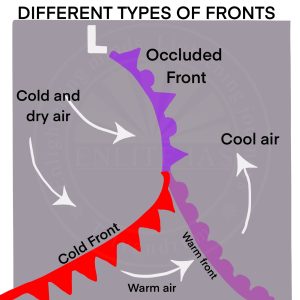
Types of Fonts
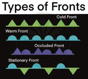
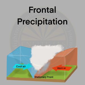
- Stationary Front
- When the surface position of a front does not change (when two air masses are unable to push against each other; a draw), a stationary front is formed.
- The wind motion on both sides of the front is parallel to the front.
- Warm or cold front stops moving, so the name stationary front.
- Once this boundary resumes its forward motion, becomes a warm front or cold front.
- Associated Weather
- Cumulonimbus clouds are formed. Overrunning of warm air along such a front causes frontal precipitation.
- Cyclones migrating along a stationary front can dump heavy amounts of precipitation, resulting in significant flooding along the front.
- Cold Front
- Such a front is formed when a cold air mass replaces a warm air mass by advancing into it or that the warm air mass retreats and cold air mass advances (cold air mass is the clear winner).
- In such a situation, the transition zone between the two is a cold front.
- The cold front moves up to twice as quickly as warm fronts.
- Frontolysis begins when the warm air mass is completely uplifted by the cold air mass.
- Associated weather
- The weather along such a front depends on a narrow band of cloudiness and precipitation.
- Severe storms can occur. During the summer months thunderstorms are common in the warm sector.
- Temperatures can drop more than 15 degrees within the first hour.
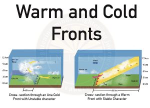
- Warm Front
- It is a sloping frontal surface along which active movement of warm air over cold air takes place (warm air mass is too weak to beat the cold air mass).
- Frontolysis (front dissipation) begin when the warm air mass makes way for cold air mass on the ground, i.e. when the warm air mass completely sits over the cold air mass.
- Associated weather
- As the warm air moves up the slope, it condenses and causes precipitation but, unlike a cold front, the temperature and wind direction changes are gradual.
- Such fronts cause moderate to gentle precipitation over a large area, over several hours.
- The passage of the warm front is marked by rise in temperature, pressure and change in weather.
- Occluded Front
- An Occluded Front forms when a warm air mass gets caught between two cold air masses.
- The warm air mass rises as the cool air masses push and meet in the middle.
- The temperature drops as the warm air mass is occluded, or “cut off,” from the ground and pushed upward.
- Associated Weather
- Weather along an occluded front is complex—a mixture of cold front type and warm front type weather. Such fronts are common in west Europe.
- The formation of a Mid-latitude cyclone