

- They are aligned in a north – east to south – west direction.
- They run for about 800 km between Delhi and Ahmedabad in Gujarat, with the width and height decreasing from Gujarat to Delhi.
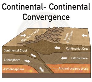
- They were formed during the Aravalli–Delhi Orogeny involving the collision of microplates, which later became part of the Indian plate.
- They continue up to Haridwar and are buried under the alluvial Ganga plains.The
- Aravallis have an average elevation in the range of 400-600m.
- Mt. Gurushikhar (1722m) is the highest point of the Aravallis.The
- Aravallis share the western border with the Thar desert and the eastern border with the Mewar plateau.
- Serves as a natural barrier against desertification and sandstorms.
- Source of important rivers such as the Chambal, Sabarmati, and Luni.
- Provide essential resources like fuelwood, fodder, fruits, and commercial products.
- Helps in regulating precipitation through evapotranspiration.
Source: The Hindu