What is it?
- The systems developing in the mid and high latitude, beyond the tropics are called the middle latitude or extra tropical cyclones.
Formation
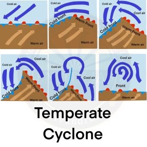
- Extratropical cyclones form along the polar front.
- Initially, the front is stationary.
- In the northern hemisphere, warm air blows from the south and cold air from the north of the front.
- When the pressure drops along the front, the warm air moves northwards and the cold air moves towards south, causing an anticlockwise cyclonic circulation.
- The cyclonic circulation leads to a well-developed extra tropical cyclone, with a warm front and a cold front.
- The plan and cross section of a well-developed cyclone is given in Figure 2.
- The warm air glides over the cold air and a sequence of clouds appear over the sky ahead of the warm front and cause precipitation.
- The cold front approaches the warm air from behind and pushes the warm air up.
- As a result, cumulus clouds develop along the cold front.
- The cold front moves faster than the warm front ultimately overtaking the warm front.
- The warm air is completely lifted up and the front is occluded and the cyclone dissipates.