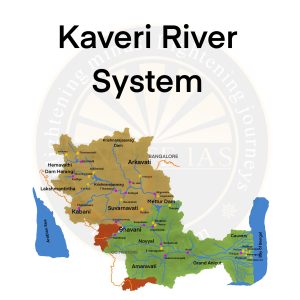
Basics
- Origin: Talakaveri on the Brahmagiri range, Kodagu (Coorg) district of Karnataka.
- Other Name: The Cauvery River (Kaveri) is designated as the ‘Dakshin Bharat ki Ganga’ or ‘the Ganga of the South’.
- Length: 800 km
- Basin States: Tamil Nadu, Karnataka, Kerala, and the Union Territory of Puducherry
- Passing States: Tamil Nadu, Karnataka.
- Borders: It is bordered on the west by the Western Ghats, on the east and south by the Eastern Ghats, and the north by the ridges that separate it from the Krishna and Pennar basins.
- Major Dams: Krishnarajasagar in Karnataka, Mettur dam in Tamil Nadu..
- Waterfall: Hogennekkal Falls.
- Important Tributaries
- Left Bank: Harangi, Hemavati, Shimsha, and Arkavati rivers.
- Right Bank: Lakshmana Tirtha, Kabbani, Suvarnavati, Bhavani, Noyil, and Amaravati rivers.
Tributaries
- Hemavathi: It rises from the Western Ghats at an elevation of about 1219 m near Ballalarayana Durga in the Chikmagalur District of Karnataka.
- Shimsha: It originates at an altitude of 914 m from the Devarayanadurga hills in Karnataka.
- Arkavathy: The River originates at Nandi Hills of Chikkaballapur district of Karnataka.
- Lakshmana Tirtha: It rises from the Irupu Falls (also Iruppu Falls), located in the Brahmagiri Range in the Kodagu district of Karnataka, bordering the Wayanad district of Kerala. It then flows eastwards and joins the Kaveri River in the Krishna Raja Sagara Lake.
- Kabini: Originates from Pakramthalam Hills in Wayanad District of Kerala. Kabini forms an island called Kuruva Island.