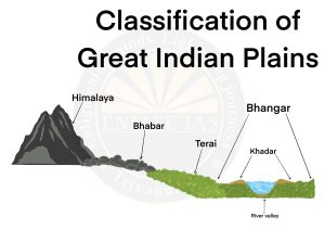
Bhabhar Region
- It is a narrow, porous, northernmost stretch of the Indo-Gangetic plain which is located parallel to the Shiwalik foothills.
- The porosity is due to the deposition of a huge number of pebbles and rock debris across the alluvial fans. Rivers disappear in this region.
- Not good for cultivation.
- Bhabhar zones stretch from Punjab to Assam Himalayas
Terai Region
- Located south of Bhabar and the width is 10 – 30 km.
- In this region, rivers reemerge creating marshy and swampy conditions.
- The western part is drier and broader whereas the eastern part is wetter and narrower.
- The region is rich in biodiversity and is now being converted for agriculture purposes.
Bangar Region
- The Bhangar is the older alluvium along the river beds forming terraces higher than the floodplain.
- The terraces are often impregnated with calcareous concretions known as ‘KANKAR’.
Khadar Region
- The Khadar is composed of newer alluvium and forms the flood plains along the river banks.
- A new layer of alluvium is deposited by river floods almost every year.