Marwar Plateau or Mewar Plateau
- It is the plateau of eastern Rajasthan.
- The average elevation is 250-500 m above sea level and it slopes down eastwards.
- The Banas River, along with its tributaries originate in the Aravali Range and flow towards northwest into the Chambal river. The erosional activity of these rivers makes the plateau top appear like a rolling plain.
Malwa Plateau
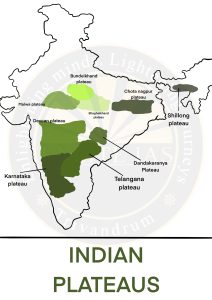
- The Malwa Plateau roughly forms a triangle based on the Vindhyan Hills, bounded by the Aravali Range in the west and Madhya Bharat Pathar to the north, and Bundelkhand to the east.
- Malwa plateau has two systems of drainage; one towards the Arabian sea (The Narmada, the Tapi, and the Mahi), and the other towards the Bay of Bengal (Chambal and Betwa, joining the Yamuna).
- The general slope is towards the north.
- They are not a very fertile region and have heavy soil degradation taking place. Deep ravines are also formed here.
Bundelkhand Uplands
- It is the oldest dissected upland of the Bundelkhand gneiss composed of granite and gneiss which spread over five districts of Uttar Pradesh and four districts of Madhya Pradesh.
- Rivers much dissect area and sustains a large farming population.
- It is covered with black soil.
Baghelkhand Plateau
- Located north of Maikal range.
- It is bounded by the Son river on the north.
- The central part of the plateau acts as a water divide between the Son drainage system in the north and the Mahanadi river system in the south.
- General elevation varies from 150 m to 1,200 m.
- The Bharner and Kaimur are located close to the trough-axis.
Chotanagpur Plateau
- Represents the north-eastern projection of the Indian Peninsula.
- It is the remnant of Singhabhum proto continent that spread across Jharkhand, West Bengal and Odisha.
- The region is rich in both organic resources like coal and inorganic resources like bauxite, and iron.
- Average elevation of the plateau is 700 m above sea level.
- The region is known for its radial drainage pattern and associated rivers are Damodar, the Subarnrekaha, the North Koel, and the South Koel.
- The Rajmahal Hills form the northeastern edge of the Chotanagpur Plateau. They are mostly made of basalt and are covered by lava flows.
Meghalaya Plateau
- The peninsular plateau extends further east beyond the Rajmahal hills to form the Meghalaya or the Shillong plateau.
- Garo-Rajmahal Gap separates this plateau from the main block.
- The western, central, and eastern parts of the plateau are known as the Garo Hills (900 m), the Khasi-Jaintia Hills (1,500 m), and the Mikir Hills (700 m). Shillong (1,961 m) is the highest point of the plateau.
Kathiawar Plateau
- Constitutes a series of small hills forming the Kathiawar peninsula.
- Gir range, Girnar range and Barda hills are prominent relief features.
- Characterised by forest region well known for Asiatic Lion and Maldari tribes.
Deccan Plateau
- It is triangular in shape and is bounded by the Satpura and the Vindhya in the north-west, the Mahadev and the Maikal in the north, the Western Ghats in the west, and the Eastern Ghats in the east.
- Average elevation is 600 m and rises to 1000 m in the south but dips to 500 m in the north.
- Its general slope is from west to east which is indicated by the flow of its major rivers.
- It has rich cover of black cotton soil
- Deccan Traps
- Traps are step like features
- Formed by volcanic activity near Reunion Island when Peninsular India shifted towards north.
- It spreads over regions like Malanad in Karnataka , Kathiawar in Gujarat, Maharashtra, and Bundelkhand.
Dandakaranya Plateau/ Bastar Plateau
- It is an undulating plateau and was a place of exile during ancient times.
- It is a forested mineral-rich region.
- It is a tribal-dominated region with the presence of Naxalism.
Chhattisgarh Plain
- It is the only plain worth the name in the Peninsular Plateau.
- It is a saucer-shaped depression drained by the upper Mahanadi.
- The whole basin lies between the Maikala Range and the Odisha hills.
- The general elevation of the plain ranges from 250 m in the east to 330 m in the west.