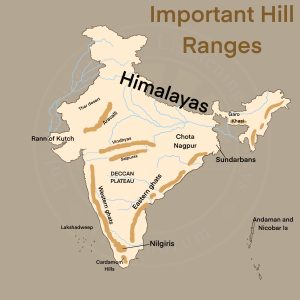
- The Eastern Ghats run almost parallel to the east coast of India leaving broad plains between their base and the coast.
- It is a chain of highly broken and detached hills starting from the Mahanadi in Odisha to the Vagai in Tamil Nadu.
- They almost disappear between the Godavari and the Krishna.
- They neither have structural unity nor physiographic continuity.
- It is only in the northern part, between the Mahanadi and the Godavari that the Eastern Ghats exhibit true mountain character.
- General elevation of 900-1,200 m and Mahendra Giri (1,501 m) is the tallest peak here.
- The Eastern Ghats reappear as more or less a continuous hill range in Cuddapah and Kurnool districts of Andhra Pradesh where they are called as Nallamala Range with a general elevation of 600-850 m.
- The southern part of this range is called the Palkodna range.