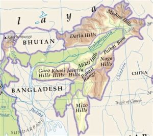
- Eastern Hills or The Purvanchals are the southward extensions of the Himalayas running along the north-eastern edge of India.
- At the Dihang Gorge, the Himalayas take a sudden southward bend (syntax bend) and form a series of comparatively low hills which are collectively called the Purvanchal.
- They run along the India-Myanmar Border extending from Arunachal Pradesh in the north to Mizoram in the south.
- Patkai Bum Hills are located in this region and the elevation varies from 2,000 m to 3,000 m. It merges into the Naga Hills where the Saramati Peak (3,826 m) is located.
- South of Naga Hills is the Manipur hills (2,500 meters) in elevation.
- The Barail range separates Naga Hills from Manipur Hills.
- South of the Manipur Hills is the Mizo Hills (previously known as the Lushai Hills) which have an elevation of less than 1,500 meters. The highest point in the South is the Blue Mountain (2,157 m).