Facts to Know
- India is located entirely in the northern hemisphere and in the south-central part of the continent of Asia.
- It is located between latitudes 8°4’N and 37°6’N and longitudes 68°7’E and 97°25’E.
- India is the 7th largest country in the world by geographical extent.
- India has a land boundary of about 15,200 km.
- The Coastline of India including both mainland and islands is 7,516.6 km and the coastal states are Gujarat, Maharashtra, Goa, Karnataka, Kerala, Tamil Nadu, Andhra Pradesh, Odisha, and West Bengal.
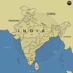
- Geographical Borders
- Himalayas – In the northwest, north, and northeast
- Indian Ocean – In the south, it is divided into the Arabian Sea on the west and the Bay of Bengal on the east.
- Standard Meridian of India (82°30’E) passing through Mirzapur (in Uttar Pradesh) is taken as the standard time for the whole country and the states through which it passes are Uttar Pradesh, Madhya Pradesh, Chattisgarh, Orissa, and Andhra Pradesh.
- Tropic of Cancer passes through – Gujarat, Rajasthan, Madhya Pradesh, Chhattisgarh, Jharkhand, West Bengal, Tripura and Mizoram.
- Extreme Points of India
- Northernmost Point of India – Indira Col
- Southernmost Points of India – Indira Point
- Easternmost Point of India – Kibithu
- Westernmost Point of India – Guhar Moti
- Southernmost Point of India in the Mainland – Kanyakumari