Trans Himalayas
- Length – 1,600 km
- Alignment Direction – Extending in a west-east direction parallel to the main Himalayan range.
- Located north of the Yarlung Tsangpo River on the southern edge of the Tibetan Plateau.
Indus Tsangpo Suture Zone
- The Indus-Yarlung Tsangpo suture is a tectonic suture in southern Tibet.
- It is spread across the northern margin of the Himalayas which resulted from the collision between the Indian plate and the Eurasian plate.
Tethian Himalayas
- Formed because of compression of sediments from Tethys sea.
- Major Ranges – Zaskar and Kailash
- It determines India’s frontiers with Afghanistan and China.
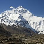
Main Himalayas
- Average height is 5000 metres.
- Lofty peaks along with extensive snowfields of glaciers.
- It is a continuous range with few passes.
- The region has antecedent rivers (The rivers that existed before the upheaval of the Himalayas are known as the antecedent rivers and they cut their courses southward by building gorges in the mountains).
- It runs from Nanga Parbat in the west (Pak-Occupied Kashmir) to Namcha Barwa in the East (Arunachal Pradesh in India).
- Major Passes
| States | Passes |
| Jammu and Kashmir | Zojila, Brazil |
| Himachal Pradesh | Bara Lapcha La, shipki La |
| Uttarakhand | Niti pass, Lipu lekh |
| Sikkim | Nathu la, Jelep La |
Lesser Himalayas
- The average height is 1300 to 5000m.
- Important ranges are Dhauladhar, Pirpanjal, Nagatibba, Mussoorie and Mahabharat range.
- Southern slopes are steep while northern slopes are rugged.
- Along slopes, small pastures are found called Merg.
Shiwaliks
- This is not a continuous range.
- It has a hog-back appearance with steeper slopes towards the south.
- It has valleys called Duns in the west and Duars in the east. For example, Dehradun in Uttarakhand.